In a presentation prepared for the Lunar and Planetary Science Conference 2013, I said that G. Jones's observations of the zodiacal light made in 1853-54 have interesting similarities to the sky position to be expected of sunlight reflected from a ring in the plane of the lunar orbit.
So that others can undertake the comparison, here is a description of how it was undertaken.
First, here is Jones's record of his observations: Jones, G. Observations on the zodiacal light, April 2, 1853 to April 22, 1855 (Vol. III, Report by Secretary of the Navy to the House of Representatives, 1856)
Second, here is the means of visualization.
(1) I used Celestia, freeware available at http://sourceforge.net/projects/celestia/. I also installed an add-on called the Lua Educational Tools.
(2) I tuned Celestia to use JPL orbits for the Earth and Moon, rather than the models that are Celestia's defaults. To do that, go to ftp://ssd.jpl.nasa.gov/pub/eph/planets/SunOS/de406/ and download the file unxp1800.406 Rename that file jpleph.dat and drop it into the celestia/data folder that was made when you installed Celestia in Step 1. (If you want to understand what the jpleph.dat file is doing, read http://en.wikibooks.org/wiki/Celestia/JPL_Ephemerides. But their directions for downloading the JPL ephemerides do not work, which is why I have provided separate instructions here.)
(3) I wrote an *.ssc file for Celestia that wraps the Earth in two rings, one in the equatorial plane and one in the plane of the lunar orbit. The file is entitled Jones2012rev.ssc. First it puts a ring around the Earth's equator - an idea I gained from an add-on devised by a Celestia user, E. Stauffer. I am so grateful.
But Celestia will only put a ring around the equator of a planet, and I wished to visualize a second ring as well, the "Jones Ring" in the plane of the lunar orbit. So my *.ssc file next adds a fake planet whose name is "moonring." This is another planet of the Sun, and it is in exactly the same orbit as the Earth. But this one is tilted; its "bodyframe" is defined by a plane containing a vector from the Earth to the Moon, and a vector tangent to the velocity of the Moon. Lo and behold, the equator of this planet is the plane of the lunar orbit. This plane is then also given rings. The "moonring" is smaller in radius than the Earth, so that it is hidden inside. It cannot be made invisible or its rings will be invisible also. From outside the Earth's surface, it appears simply that the Earth has two rings.
Each planet shades only its own rings (Celestia limitation in current version). I do not think either ring shows the shade that it casts on itself, but I am not sure of that; I just look to see what the Sun is illuminating in order to work out what is shaded.
As for the structure of the rings themselves: Each has the same density structure, entitled ruler.png. It has a sequence of ringlets at measured radii by which I can compare sky positions to the ringlet radii that could cause such an effect. For the key that associates ringlet colors with radii, see note further down this page.
(4) Next I prepared another *.ssc to show Jones's position at each listed observation 1853-54. This is entitled ShipSites.ssc.
(5) And then I prepared a spreadsheet with Celestia URLs, one for each of Jones's observations. A reader who has Celestia installed as above will then land at Jones's position, numbered observation by numbered observation. This is entitled ShipSites.xlsx. If you use these you will find yourself located where Jones was, only 4 km straight up in the air, at sunrise or sunset depending on the time of his observation. Then you simply run time forward or backward, and/or make the field of view rotate to make the ecliptic perpendicular, and so on, to achieve a visualized sky view that you can compare to the sky view to the area/time he sketched.
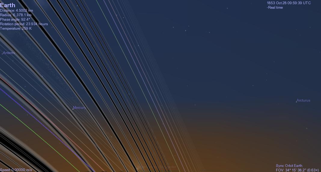
For example, clicking on "Observation 74" would open Celestia and place the observer as below - facing west at sunset, at about 22.4N, 113.5E, as it all was on October 28, 1853. Here the southern sky (to the left) shows two rings. If the user then causes Celestia's time to run forward, the user will observe that the equatorial ring stays in place but the Jones ring moves as the "night" passes. The sky appearance can then be compared to Jones's report per Observation 74 - bearing in mind that the visualization below does not incorporate self-shading, and shows for each ring only the shade of its "own" planet.
In my opinion, the comparison shows that Jones's observations are consistent with interpretation as a record of an Earth ring in the plane of the lunar orbit. They are less consistent or not consistent with interpretation as a ring around the Sun in the plane of the ecliptic.
**************************************
Key to the ruler.png file.
The *.ssc files indicate that the rings are to be implemented from zero to 512,000 km from the center of the earth. Each graphic is of length 4096 pixels - thus, 8 pixels/1000 km. Provided the user does that, simply adopting the *.ssc files as given, here is the key to the ring colors/ringlet radii:
BLACK
Ringlets at 63, 72, 80, 89, 96, 103, 111, 119, 128, 135, 144, 153, 161 pixels
Thus approximately (in '000 km) 8, 9, 10, 11, 12, 13, 14, 15, 16, 17, 18, 19, 20
GREEN: 200 pixels - that is, 25K km from center of earth
BLUE: 240 - that is, 30K
km from center of earth
RED: 280 - that is, 35K
km from center of earth
YELLOW: 320 - that is, 40K
km from center of earth
BLACK AGAIN:
400 - that is, 50K km from center of earth
480 - that is, 60K
km from center of earth
560 - that is, 70K
km from center of earth
GREEN AGAIN:
640 - that is, 80K
720 - 90K
800 - 100K
880 - 110K
960 - 120K
1040 - 130K